The Olympic Rain Shadow
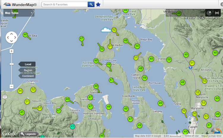
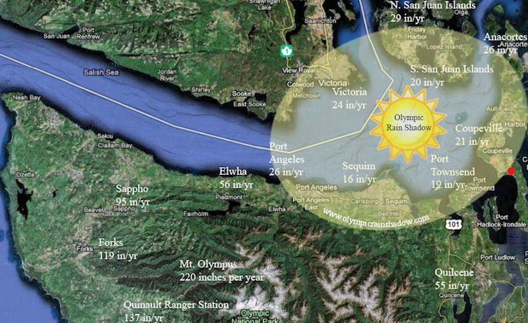
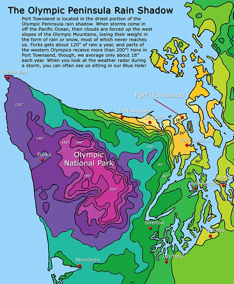
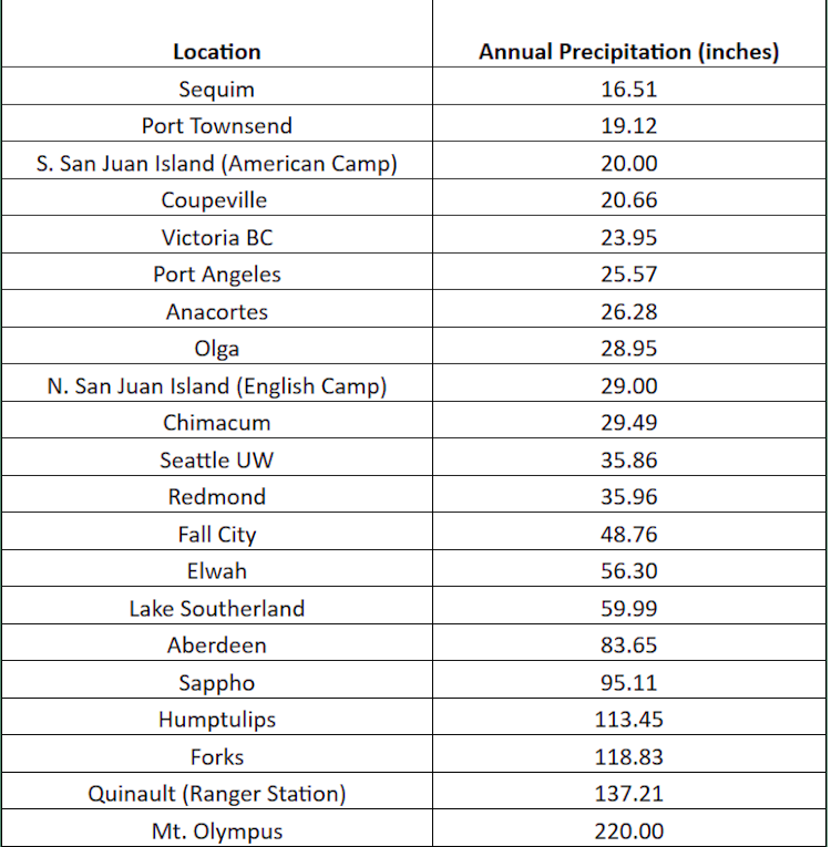
Located between Coupeville & Port Townsend, Admiral's Cove is protected by the Olympic Rain Shadow. Statistics show that the nearby communities of Port Townsend and Coupeville each receive about 19 and 21 inches of rain per year respectively.Located in the Dungeness Valley on Washington's Olympic Peninsula, Sequim lies in the heart of the Rain Shadow. With an average of about 16 inches of rain per year it is the Shadow's Dry Spot. To a lesser extent, the rain shadow effects other areas around the Olympic Peninsula including Port Angeles, the San Juan Islands, Anacortes and Victoria on Vancouver Island in British Columbia. As shown on this rainfall map of the area you can see how dry it is in the Rain Shadow and how wet it is on the other side of the Olympic Mountains. One interesting statistic: Port Angeles receives about 27 inches of rain a year; but as you go west from there rainfall increses by one inch for every mile you travel westward.
The Mountain Shadow Effect
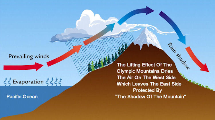
The Olympic Mountains act as the wall that forms the Olympic Rain Shadow that protects Admiral's Cove and northern Whidbey Island from the bulk of the rain that moves into the Pacific Northwest.As winds carry wet air in from the Pacific and push it up against the Olympic Mountains. The air is forced up to higher altitudes, where the atmospheric pressure is lower. The air expands and cools and can't hold as much water vapor. Tiny water droplets coalesce and clouds form. If there is enough moisture in the air, and if the temperature is cool enough, the droplets become rain drops and they fall to Earth. Over 12 feet of rain falls on the west side of the mountains annually allowing the Hoh and Quinault Rain Forests to flourish. Giant Western Hemlocks, Douglas Firs and Sitka Spruce trees dominate the landscape while Ferns cover the forest floor and moss cloaks the trees.
Then the air warms up again as it goes down the east side of the Olympic Mountains and into the Puget Lowland or Willamette Valley. The air gets warmer because it is under higher pressure at the lower altitudes. Warm air can hold more water vapor than cold air. So even if there is still moisture in the air as it descends into the valleys, the moisture is less likely to condense into rain and stays "trapped" in the warm air.
Pacific Northwest Rain Shadow
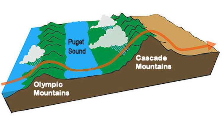
Since the valley between the Olympic and Cascade Mountains is in the rain shadow, the area is a bit drier and warmer than the coast.The smaller the mountains, the weaker the rain shadow effect, so the rain shadow cast by the Olympic Mountains is not as strong as the one cast by the Cascade Mountains.
As the winds move the air further east, the process is repeated when this moisture-laden air runs into the Cascade Mountains. The air is again forced upwards, cools, and water falls as rain. Or snow, if it's cold enough. The Cascades are a much more formidable barrier than the Olympics, and so much rain is dropped from the air after hitting the western flanks of the Cascades that very little moisture is left when the air reaches the other side.
Convergence Zone
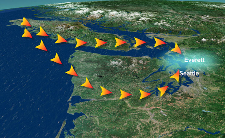
The Puget Sound Convergence Zone works best when there is a northwest flow in the upper atmosphere, and unstable air. They tend to be most frequent following a storm system, as usually winds blow from the northwest following a cold's front passage. Those northwest winds will collide with the Olympic Mountains. Some of the air flow is deflected east down the Strait of Juan de Fuca, while the rest of the air is deflected down the western side of the Olympics.When the northern branch reaches the I-5 Corridor and the Cascade Mountains, it will then be forced to the south. Meanwhile, when the southern branch reaches the I-5 corridor and Cascade Mountains past the southern side of the Olympics, it will then turn to the north.
Eventually, the south-flowing branch and the north-flowing branch will converge. When that happens, the air has nowhere to go but up. Rising air leads to convection which will lead to cloud and storm development.
Source: ABC KOMO 4 News
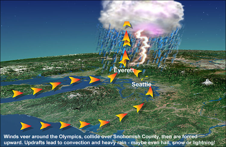
Convergence Zone
Most Convergence Zones are strong enough to produce rain, but depending on how strong the winds are, and if the atmosphere is unstable, you can get strong thunderstorms, hail, or on cold days, heavy snow. In fact, the Convergence Zone is a frequent culprit of giving its area a snow that the rest of the region misses out on. It will also bring very heavy snows to the Cascades wherever it sets up -- usually between Stevens and Snoqualmie Pass.Instability occurs when you have much colder air moving into the upper atmosphere -- it makes it easier for clouds to form since the warm air from the surface can rise higher and faster. Usually also occurs with cold air moving in after a cold front passage.
The Convergence Zone's favorite spot tends to be an east-west line that extends over the central and south Snohomish County area which makes Lynnwood, Edmonds, Mukilteo, Mill Creek, Mountlake Terrace, Shoreline, Bothell and Everett the prime spots. However, just to make forecasting a challenge, the Zone can move, depending on the strength of each wind component. If the south component becomes stronger, it will push the Zone further north, and vice versa.